In late October 2024, a DANA storm dropped more than 200 liters of rain per square meter over the province of Valencia in just a few hours. The consequences were catastrophic: hundreds of lives lost and a landscape devastated by the force of the water—especially in the southern metropolitan area, where the Rambla del Poyo, an apparently harmless dry streambed, turned into a deadly trap.
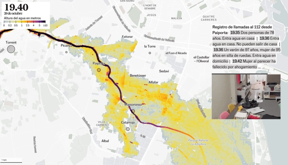
Thanks to a hydrodynamic simulation developed by a research team at the Universitat Politècnica de València, the visual journalism team from El País gained access to an unprecedented model: a minute-by-minute reconstruction of how the floodwaters advanced from the ravine into neighborhoods like Picanya, Xirivella, and the outskirts of Valencia.
This interactive visualization was a challenge both technically and narratively. Our main goal was to convey to readers the extraordinary nature of the flood: how protective systems collapsed, and how official alerts came far too late. The simulation makes it clear that by the time the warning reached the population, much of the area was already under more than 1.5 meters of water.
The key component of the project is the scroll. Readers control the simulation as if scrubbing through a video: scrolling down advances the timeline, scrolling up rewinds it. This effect is achieved by interpolating between coordinates and zoom levels.