Mexico has 30% of its land under high seismic risk
Context
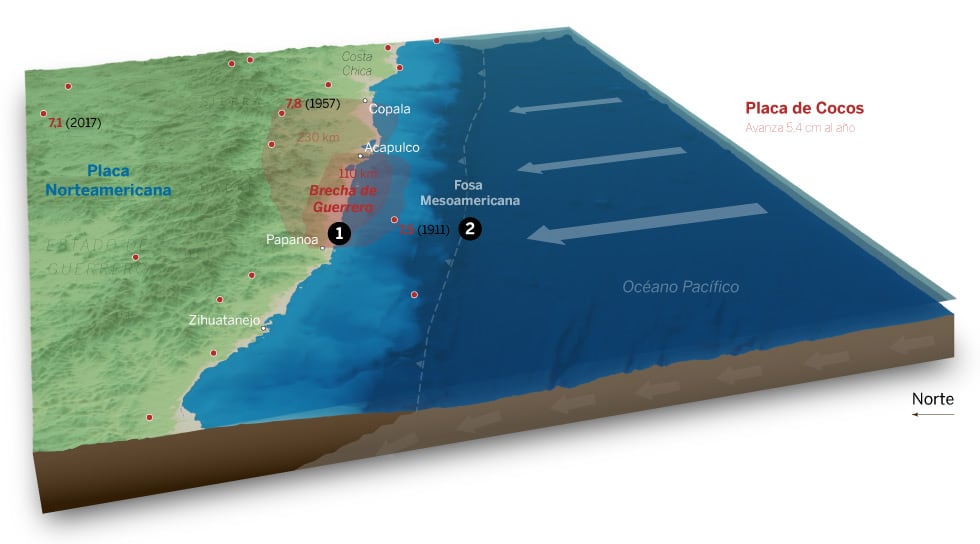
This story examines seismic risk in Mexico with a focus on the Guerrero Gap, a roughly 110 km segment with no major earthquake recorded for more than a century despite intense regional seismicity.
My role
- Data analysis
- Cartography
- Frontend development
I produced the cartographic narrative and technical map workflow, combining risk context, historical earthquake records, and explanatory graphics for a general audience.
I also built the terrain-ready data pipeline used in the opening locator map, including DEM and bathymetry preparation for Blender rendering.
Data and methodology
The piece linked tectonic context (Cocos and North American plate subduction), the mapped Guerrero seismic gap, and all magnitude 7+ events in the area since 1911.
For 3D relief, I processed elevation and bathymetry with GDAL scripts: value filtering above/below sea level, raster resampling to common resolution, merge, and nodata filling.
I used a Blender heightmap workflow inspired by Daniel Huffman and Nick Underwood's blenderize utilities to prepare relief-ready surfaces.
Key decisions
- Used Blender only where terrain perception added value (the opening locator), keeping the rest of the story in clearer 2D explanatory maps.
- Designed responsive ai2html graphics so dense labels and tectonic annotations remained readable across phone, tablet, and desktop.
- Prioritized explanatory layering over visual spectacle, pairing each map with concise tectonic and hazard context.
Result
The final feature translated a technically complex seismic topic into a readable visual explanation of where risk accumulates and why the Guerrero Gap matters.
Impact and learnings
- The project reinforced a reusable workflow for combining geospatial scripting, shaded-relief production, and newsroom-ready explanatory cartography.